Benthic Habitat Assessment Program (BHAP)
Project Leader:Trey Spearman, Project Manager
Project Details
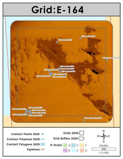
Figure 1. An example of a side-scan image mosaic created from a square nautical mile survey off the coast of Alabama.
Background:
The benthic habitat assessment program of the Fisheries Ecology Lab developed from a need to assess marine benthic habitats in an accurate and efficient manner. Using bathymetric and side-scan sonar, benthic habitats ranging from oyster reefs, seagrass beds, and artificial and natural reef structures have been mapped in the nearshore and offshore coastal areas of Alabama since 2007. These data are used in support of a wide variety of research projects of the University of South Alabama’s Department of Marine Sciences and the Dauphin Island Sea Lab.
Objectives:
The objectives of the program are to collect and analyze sonar data to create detailed benthic habitat maps and reports as well as produce spatial data consumable by a variety of geographic information systems (GIS). Project goals include pre and post oyster reef construction assessment, seagrass bed delineation, and offshore reef location and density estimations.
Approach:
Side-scan sonar is used to create georeferenced mosaic images of large areas of the sea floor while the swath bathymetry is utilized to create high-resolution 3D imaging. The data collected from these systems are used in target detection, base image creation and bottom classification (Figure 1). All data collected are stored, managed and disseminated via a geographic information system (GIS)
Results to Date:
During the course of our oyster reef surveys nearly 70 km2 of the bottom was mapped. The offshore assessment work continues, and at this point 460+ km2 of seafloor has been mapped within and around Alabama’s Artificial Reef Permit Zones. From this effort the locations of over 10,000 individual reefs have been determined. The offshore assessment effort has proven to be essential in providing the sampling framework for the Fisheries Independent Survey of the Fisheries Ecology Lab.
Funding Sources: NOAA SEAMAP, NOAA MARFIN, ADCNR, DISL, and NFWF Wildlife and Sportfish Restoration Fund.