What good is a salt marsh - and how were they affected by the Deepwater Horizon oil spill? A recent paper published in Environmental Science & Technology by ACER’s Nitrogen Cycling group has added important data to the more recent perspective of salt marshes as critical coastal ecosystems.
While other civilizations may have harvested their hay or rose hips, had sheep graze on their grasses, or simply enjoyed the natural beauty of salt marshes, in the past century, humans have viewed these wetland ecosystems as smelly, mosquito-breeding, useless habitats in need of reclamation. In the recent paper titled Vegetation loss decreases salt marsh denitrification capacity: implications for marsh erosion[1], ACER’s Nitrogen Cycling team investigated the effect of the Deepwater Horizon oil spill on a critical ecosystem process, nitrogen cycling, and concluded that while the oil spill did not directly affect rates of denitrification, exposure to oil can accelerate marsh erosion via marsh die-off, changing the habitat to bare mudflat which then affects nitrogen cycling. ACER’s Nitrogen Cycling team is lead by Dr. Behzad Mortazavi of the Dauphin Island Sea Lab and the University of Alabama and Dr. Patty Sobecky of the University of Alabama.
One of the major human impacts to coastal regions has been the increased amount of nitrogen entering from upland and upriver regions. It is well documented that this excess nitrogen is associated with a suite of ecological problems, most notably hypoxia and harmful algal blooms. For example, excess nitrogen fertilizer coming from the breadbasket of the United States enters the Mississippi River, travels to the Gulf of Mexico and results in a region of seasonal hypoxia that has become known as the “Dead Zone”. Any process that would reduce this nitrogen input would be beneficial. As discussed in a prior edublog, one such process is denitrification, the transformation of nitrate to nitrogen gas that can then diffuse from the water.
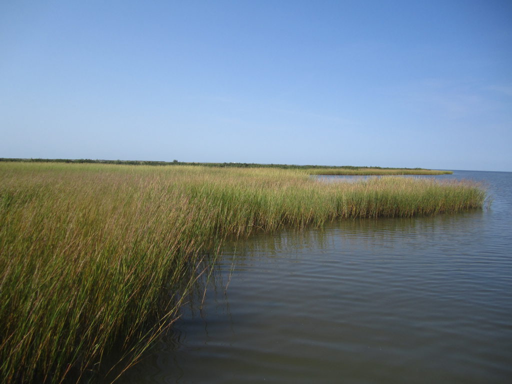
This study compared the rates of denitrification in salt marsh sediments to those in unvegetated (bare) sediments in the Chandeleur Islands, ACER’s primary study site, over a period of 7 months.
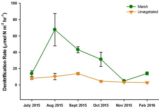
In short, they found that rates of denitrification capacity, the ability to remove nitrogen from the aquatic system, was approximately four times greater in marsh sediments that in adjacent bare sediments - a removal rate of 3.6 tons of nitrogen per square kilometer per year vs 0.9 t N km-2 y-1, respectively. While there were seasonal differences, in 4 out of 6 sampling periods, denitrification capacity was significantly higher in salt marsh sediments.
While samples for this work came from an area that experienced moderate levels of oiling as known from SCAT maps created during the oil spill; however, at the time of this study, 5 years later, the total petroleum hydrocarbon (TPH) levels where they collected sediment were near or below the limit of detection. While the effect of the oil spill on denitrification rates immediately following the spill is not known, using data from other studies in the area, they found that the measured rates were not significantly different from denitrification rates measured prior to the oil spill, indicating ecosystem resilience of the denitrification capacity of salt marshes (if the marsh survived the initial oiling disturbance).
To tease out the cause of these differences in denitrification capacity, the research team also sampled the microbial community, the groups of bacteria responsible for carrying out the transformations of nitrate to nitrite and nitrite to nitrogen gas. A qPCR analysis of genes that function in the denitrification pathway in these groups would determine whether denitrification was lower in the bare sediments because the bacteria were absent or low in abundance, or that they were there, but less active due to other constraints. Their results indicated that bacterial abundances were similar in salt marsh and in bare sediments, leading to the conclusion that other constraints were affecting the level of activity in the bacteria. One of the possible constraints may be the level of carbon in the sediment, the food if you will, for the bacteria. Carbon levels were significantly lower in bare sediments than in salt marsh sediments.
Salt marsh areas are declining globally. This decline, by as much as 50% in the last century, has been documented in Europe, Australia, China and here in North America. To readers in the Gulf of Mexico area, perhaps the most familiar case is Louisiana where we lose a football field of coastline every 100 minutes[2], much of that being salt marsh. The DWH event accelerated this loss of salt marsh habitats; rates of marsh erosion were 200% greater in oiled areas than unoiled areas 2.5 yrs after the spill[3], likely due to vegetation die-off.
So what good is a salt marsh? The results of this study by ACER’s Nitrogen Cycling team showed that the critical ecosystem service of nitrogen removal via denitrification was significantly less in unvegetated sediments than in salt marsh sediments. These results coupled with this documented loss of salt marsh habitats allows one to conclude that the impacts of DWH were not to directly reduce rates of nitrogen removal capacity through effects on the microbial community but to indirectly decreases rates of nitrogen removal through loss of salt marshes. With a documented value of $14,397 per hectare per year[4], 66% being attributed to nutrient transformations and removal, a loss of 1000 square kilometers or 100,000 hectares such as that documented for Louisiana from 1985-2010, would cost just shy of $1 BILLION in lost nutrient removal. Now that figure just may shift your perspective of salt marshes!
Additional Resources
Data associated with this work are publicly available through the Gulf of Mexico Research Initiative Information & Data Cooperative (GRIIDC) at http://data.gulfresearchinitiative.org under the following DOIs: 10.7266/N7GX48KH, 10.7266/N7C53HWJ, 10.7266/N7MK69XZ, 10.7266/N79P2ZR9, 10.7266/N75X271C, 10.7266/N7154F44.
Sources
[1] Hinshaw, S.E.; Tatariw, C.; Flournoy, N.; Kleinhuizen, A.; Taylor, C.; Sobecky, P.A.; Mortazavi, B. 2017. Vegetation loss decreases salt marsh denitrification capacity: Implications for marsh erosion. Environmental Science & Technology. 51(15), 8245-8253.
[2] Couvillion, B.R.; Beck, H.; Schoolmaster, D.; Fischer, M. 2017. Land area change in coastal Louisiana (1932 to 2016). U.S. Geological Survey Scientific Investigations Map 3381, 16 p. pamphlet, https://doi.org/10.3133/sim3381.
[3] Turner, R.E.; McClenachan, G.; Tweel, A.W. 2016. Islands in the oil: Quantifying salt marsh shoreline erosion after the Deepwater Horizon oiling. Marine Pollution Bulletin. 110, 316−323.
[4] Gedan, K.B.; Silliman, B.R.; Bertness, M.D. 2009. Centuries of human-driven change in salt marsh ecosystems. Annual Review of Marine Science. 1, 117−141.