For the 10th straight year, a team of researchers from the Dauphin Island Sea Lab and the University of South Alabama are mapping benthic habitats along the Gulf Coast. Benthic habitats are a variety of natural or artificial seafloor habitats such as sub-tidal oyster reefs, seagrass beds, mud flats, or reef pyramids.
The Acoustic Benthic Habitat Assessment Program (ABHAP), led by Stan Bosarge, program manager and senior research laboratory manager of the Fisheries Ecology Lab, was conceived as a way to map the spatial extent of oyster resources within Mobile Bay and the Mississippi Sound.
"This was important as it has provided a spatial framework for restoration and resource planting efforts by the Alabama Marine Resources Division," Bosarge said. "The last time these habitats were comprehensively mapped was in 1968, followed by a more directed and reduced 1995 survey, and our effort was the first survey in Alabama to utilize side-scan sonar, which is very well suited for this type of habitat mapping."
In 10 years time, the team expanded their work to include the mapping of seagrass beds and oyster breakwaters in Portersville Bay, offshore natural and artificial reef habitats within and outside of the Alabama Artificial Reef Permit Zone, as well as inshore and nearshore constructed reef areas within Mobile Bay and off of Orange Beach and Gulf Shores.
The BHAP was also instrumental in the natural resource damage assessment after the Deepwater Horizon Disaster in 2010.
"Our ability to rapidly map sub-tidal oyster resources helped in locating oyster reef habitat along coastal Louisiana to be sampled. We also processed acoustic data to identify additional oyster sampling locations in the panhandle of Florida and coastal Mississippi," Bosarge said. "This work helped to create a Gulf-wide template to facilitate resource sampling for the Oyster NRDA, whose role was to estimate damage to oyster resources."
Three years into their work the ABHAP expanded their survey offshore in support of various offshore fishing projects including the Fisheries Independent Ecosystem Survey (FI), a project co-managed by Dr.'s Sean Powers and Marcus Drymon of the Dauphin Island Sea Lab and the University of South Alabama's Department of Marine Sciences.
"Our work will hopefully lead to more accurate stock assessments of reef associated species like snapper, grouper complex and trigger fish," Bosarge explained. "Knowing where reefs are located, what types of reefs they are and how close they are to each other are essential for understanding reef fish recruitment patterns, juvenile to adult movement/migration and overall fish diversity and biomass associated with each reef type."
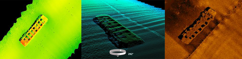
The team recently upgraded their mapping equipment to a multi-phase interferometric side-scan sonar along with an ultra-high resolution inertial navigation system.
"The new equipment allows us to paint a more complete and finely detailed three dimensional picture of the physical structure of benthic habitats," Bosarge said. "The third dimension will now let us reliably know size and complexity of offshore reef habitats, or overall elevation of oyster reefs in addition to aerial extent."
These data may provide more detailed insight into how these variables affect catch rates of red snapper, grouper and other species of concern. Additionally, this data will aid state resource managers with potential placement of future artificial reefs as well as more accurate volume estimations of oyster reefs for future enhancement or restoration efforts of oyster habitat.
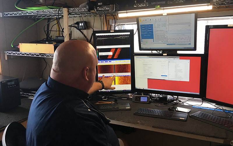
Stan Bosarge discusses Sonar from Dauphin Island Sea Lab on Vimeo.